Digital Twin for Urban Planning has rapidly emerged as a transformative force behind modern smart city development. Within the first stages of any major infrastructure or urban innovation project, governments now rely on digital twins to create accurate virtual replicas of buildings, utilities, transportation systems, and entire urban districts. These interactive models allow planners to simulate scenarios, predict outcomes, and make informed decisions that improve both efficiency and quality of life.
- Understanding What a Digital Twin Really Is in Urban Planning
- Why Governments Are Adopting Digital Twin for Urban Planning
- How Governments Use Digital Twin Systems in Smart City Projects
- Digital Twin-Driven Infrastructure Development
- Use in Transportation and Smart Mobility Planning
- Environmental and Climate Simulation
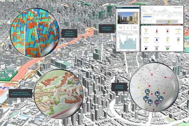
- Utility and Resource Management
- Emergency and Disaster Scenario Planning
- Public Engagement and Participatory Planning
- Case Studies: Real-World Digital Twin Applications in Governments
- Singapore: World-Leading National Digital Twin
- Barcelona: Smart Mobility and Climate Management
- United Kingdom: National Digital Twin Programme
- China: AI-Powered Urban Digital Twins
- IoT Sensors and Real-Time Data Streaming
- Artificial Intelligence and Predictive Analytics
- GIS Mapping and 3D Visualization Software
- Cloud and Edge Computing
- Open Data and Interoperability Standards
- Challenges Governments Face When Adopting Digital Twin Systems
- High Costs and Infrastructure Investments
- Data Privacy and Cybersecurity Concerns
- Interoperability Between Agencies
- Skill Gaps and Workforce Training
- Future Trends: The Next Evolution of Digital Twin in Government Planning
- City-Scale Autonomous Simulation Platforms
- Integration with Metaverse Urban Planning Tools
- AI-Assisted Policy Forecasting
- More Open Urban Data Ecosystems
- Frequently Asked Questions
- Conclusion: Why Digital Twin for Urban Planning Is Transforming Smart Cities
As cities face challenges like rapid urbanization, climate change, and resource constraints, this technology is proving invaluable. It brings together real-time data, predictive analytics, and 3D modeling to offer a comprehensive view of how a city functions — and how it can evolve sustainably.
In this article, we explore the science, technology, and real-world applications of digital twin systems in government-led smart projects, supported by examples and authoritative research.
Understanding What a Digital Twin Really Is in Urban Planning
A digital twin is more than a 3D model; it is a living, continuously updated simulation of a physical environment. In the context of cities, digital twins integrate data from sensors, GIS platforms, IoT devices, transportation feeds, and climate forecasting tools.
This creates a dynamic ecosystem in which government planners can study mobility, energy consumption, population density, infrastructure performance, and environmental impact — all before making any real-world changes.
According to a report by Deloitte, digital twins can reduce infrastructure development time by up to 20% and improve cost efficiency by up to 15%.
Why Governments Are Adopting Digital Twin for Urban Planning
Urban planners face increasing pressure to make data-driven decisions, and digital twins provide the foundation for precision planning. The technology allows for scenario simulation, risk assessment, public engagement, and long-term forecasting — all of which are essential in building future-ready smart cities.
Governments also benefit from cross-department integration. Transportation, energy, water management, waste systems, and public safety agencies can collectively work within the same virtual ecosystem. This removes silos and improves efficiency.
Furthermore, as climate resilience becomes a priority, digital twins help model the effects of floods, heatwaves, rising sea levels, and severe weather events, giving cities better preparedness strategies.
How Governments Use Digital Twin Systems in Smart City Projects
Below is a deeper, step-by-step breakdown of how digital twin technology is used in real government planning workflows.
Digital Twin-Driven Infrastructure Development
Digital twins allow urban planners to build virtual infrastructure prototypes before construction begins. This reduces expensive rework and helps validate designs.
For example, Singapore’s Virtual Singapore project enables authorities to simulate construction impacts, wind flow, traffic interactions, and shadow projections in a realistic 3D digital twin of the city.
Use in Transportation and Smart Mobility Planning
Traffic congestion is one of the biggest challenges in dense cities. Digital twins incorporate real-time traffic feeds, public transit data, and pedestrian flow analytics to predict mobility patterns.
Cities like Helsinki simulate future mobility networks using digital twins, helping reduce emissions and enhance mass transit design.
Environmental and Climate Simulation
Urban heat islands, flooding, and pollution hotspots can be modeled with sophisticated environmental layers inside digital twins.
Research from MIT Urban Modeling Lab shows that heat island simulations can improve cooling strategies in high-density areas.
Governments use these insights to create climate-resilient zoning laws, flood mitigation strategies, and sustainable green infrastructure.
Utility and Resource Management
Digital twins integrate water, electricity, waste, and telecom systems into a unified view. Planners can identify resource stress points and predict future demand.
For example, Dubai Municipality uses digital twins to manage utilities and improve energy efficiency across the city.
Emergency and Disaster Scenario Planning
Governments rely on digital twins to simulate earthquakes, fires, pandemics, and infrastructure failures.
During COVID-19, several European cities used building-scale digital twins to model ventilation, human density, and infection spread patterns, resulting in improved safety protocols.
Public Engagement and Participatory Planning
Interactive digital twin dashboards allow citizens to visualize future developments, giving transparency to public decision-making.
Cities like Rotterdam leverage digital twins during community engagement workshops to gather feedback before approving new zoning regulations.
Case Studies: Real-World Digital Twin Applications in Governments
Singapore: World-Leading National Digital Twin
Virtual Singapore is one of the world’s most advanced government-led digital twin projects. Its detailed 3D model integrates environmental data, architectural information, and IoT feeds.
Planners use it to study energy consumption, transportation behavior, emergency response patterns, and environmental sustainability.
Barcelona: Smart Mobility and Climate Management
Barcelona’s digital twin framework helps simulate thousands of transportation scenarios, improving traffic flow and reducing emissions. The city also uses climate models to plan heat adaptation strategies.
United Kingdom: National Digital Twin Programme
The UK launched a comprehensive digital twin initiative to interconnect energy, transportation, water, and environmental systems.
Its goal is to create a resilient, interoperable digital ecosystem that supports long-term national infrastructure planning.
China: AI-Powered Urban Digital Twins
Cities like Shanghai and Shenzhen deploy AI-enhanced digital twins that analyze population patterns, economic activity, and urban performance.
These models help optimize zoning decisions and the placement of public services.
Technology Enablers Behind Digital Twin for Urban Planning
Digital twins rely on various advanced technologies that collectively build a high-fidelity simulation environment.
IoT Sensors and Real-Time Data Streaming
IoT networks capture data from roadways, buildings, utilities, and environmental sensors. These inputs update the digital twin continuously, improving accuracy.
Artificial Intelligence and Predictive Analytics
AI analyzes historical and real-time data to forecast patterns like traffic congestion, energy usage, or disaster impact.
GIS Mapping and 3D Visualization Software
Geospatial systems form the foundation of digital twin mapping, integrating layers of land use, infrastructure, and environmental data.
Cloud and Edge Computing
These allow fast computation, storage, and visualization of massive datasets at national or city scales.
Open Data and Interoperability Standards
Initiatives like ISO 23247 and the FIWARE framework ensure governments can integrate data from multiple vendors or agencies smoothly.
Challenges Governments Face When Adopting Digital Twin Systems
Digital twin implementation is not without challenges, and governments must address several limitations.
High Costs and Infrastructure Investments
Developing a national-scale digital twin requires substantial capital, data collection efforts, and long-term maintenance.
Data Privacy and Cybersecurity Concerns
Because digital twins use urban-level data, strict governance and security frameworks must be in place.
Interoperability Between Agencies
Government departments often use different systems, making integration a complex process.
Skill Gaps and Workforce Training
Planners, GIS experts, and public officials need training in simulation-based decision-making.
Future Trends: The Next Evolution of Digital Twin in Government Planning
As technology advances, digital twins are expected to evolve into even more immersive and AI-driven systems.
City-Scale Autonomous Simulation Platforms
Cities will soon run continuous simulations to optimize daily operations autonomously.
Integration with Metaverse Urban Planning Tools
Virtual reality will allow citizens and planners to walk through proposed developments in a shared digital environment.
AI-Assisted Policy Forecasting
Governments will use digital twins to predict social, economic, and environmental outcomes of policy decisions before implementation.
More Open Urban Data Ecosystems
Public-facing digital twins will become common, promoting transparency and citizen involvement.
Frequently Asked Questions
What is a Digital Twin for Urban Planning?
It is a virtual simulation of a city or region that uses real-time data and analytics to model infrastructure, mobility, utilities, environmental factors, and urban growth scenarios.
How do governments use digital twins?
Governments use digital twins to simulate development, identify risks, optimize resources, improve mobility, prepare for disasters, and design smarter urban policies.
Is digital twin technology expensive for governments?
Yes, initial investment can be high, but research from McKinsey shows that digital twins can reduce infrastructure maintenance costs by up to 25%.
Are digital twins useful for climate resilience?
Absolutely. They help forecast flooding, heatwaves, air quality, and energy demand, allowing cities to plan climate adaptation strategies effectively.
Conclusion: Why Digital Twin for Urban Planning Is Transforming Smart Cities
Digital Twin for Urban Planning has become a pivotal tool helping governments envision, simulate, and improve future cities before executing real-world change. It empowers planners with data-driven insights, predictive modeling, and immersive visualization, allowing smarter, more resilient decisions.
From mobility optimization to climate response and public participation, digital twins shape the next generation of urban innovation. As global cities continue to evolve, the technology will remain at the heart of sustainable development, ensuring better planning, safer environments, and improved quality of life for all.